Dales and Lakes Bicycle Tour 2020: Day 3

“The
Howgills” said the right-pointing sign in the centre of Sedbergh and I turned
into the narrow opening with the name “Howgill Lane” emblazoned up on the
corner wall. Must be the right place then! I’d wanted to explore this route for
decades.
If you have
ever travelled on the M6 motorway in England you pass through an amazing
looking gorge near Tebay services. The Lune Gorge. Howgill Lane runs through the dreamy-looking valley below.
I’d had a
deliberately slow morning; drying clothes and the flysheet. I did not set off
until just after mid-day. This would be a shorter and less epic day so all was
well. Howgill Lane kicked up immediately and I was followed by a couple on a tandem.
They powered past me and turned off to the right at the top of the first climb,
following the Lakes and Dales Loop signpost.
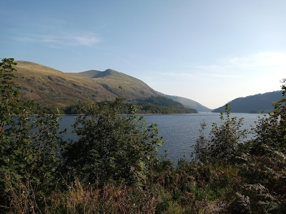
I pressed on along a series of Toblerone-style rollers with the Howgill Fells protecting my right flank from the Lost World beyond. I dropped down to the valley floor and rode abreast with the meandering Upper River Lune for too short a time. Good company. Cocooned in the splendour of this natural microworld the truckers, duckers and divers, careering along the motorway above, were out of sight, sound and mind down there.
 |
| Approaching the Lune Gorge |
Rising up from the haven of Dingley Dell I returned to the real world, criss-crossing the motorway and looping around through an attractive pine forest set in the jaws of the gorge that stand guard to the village of Tebay. The eponymous motorway service station has been voted the best in Britain. It is both excellent and popular! To the south, the truck stop at Junction 38 is run by the same people but the food is a couple of quid cheaper.
I ducked and
dived my way to the J38 cafeteria, but I didn’t look much like a trucker (should've ridden a Surly!). Seriously though, this is a handy stop for the long-distance
cyclist; with decent food, reasonably priced. There are also plenty of shower
facilities. They looked immaculate but I didn’t use them. At the back, I was
able to lock-up right outside the window in which I sat to eat a tasty chicken curry.
 |
| Yum. |
Post-lunch I set about finding my way to Shap. There is a disorienting spaghetti junction of lanes here so I closed my eyes, picked one and went for it!
Actually, with the antics of the previous day
still raw, paranoia had me checking directions on my phone frequently. As
I progressed along the peaceful lanes, under leaden skies, I stopped on the crest of each
rise to get a route-check, re-instilling confidence in my navigation.
 |
| Shap Fell: a big lump of green |
The B6261 feeds in across Shap Fell from the east along moderate slopes. There are some remote steeper sections near the summit that evoked memories of the more epic moorland climbs the previous day.
 |
| Crossing Shap Fell close to the M6 motorway |
Weirdly, at the point where the carriageways split, I found myself riding with the north-bound M6 to my left and the south bound M6 to my right. The road eventually reaches Orton then connects to the Shap motorway junction and the A6, just to the south of Shap village itself.
 |
| Arriving at the M6 (opposite direction)/A6 connecting road |
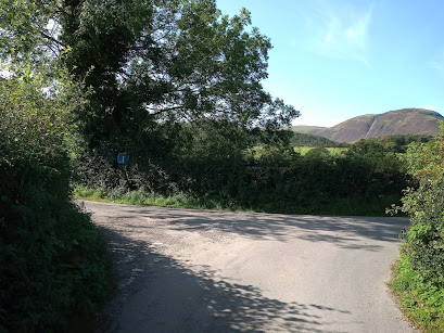
Finding Rosgill is straightforward as long as you don’t miss the left turn into Keld Lane just before leaving Shap village (heading north). The junction is slightly hidden but a large sign for Haweswater, Bampton Grange and Askham helps out.
The surrounding pastures ebb and flow mirroring the silvery River Lowther that twists through them. Oh yes, back in the Eden catchment! Clustered around the remains of Shap Abbey, dry-stone walls bring a sense of order to these fields.
A few kilometres in, Croft House appears; tents and campervans organised around the perimeter of the large camp-ground adjacent to the farmhouse. It was not full and they were sort of expecting me, I was only twenty-four hours late after all. I got the pick of two numbered pitches at the back of the field. I judged number seven to be slightly the flatter.

Corinne and John run the farm these days, as well as bringing up a young family. The camping runs from April to the end of September. They are fans of cycle touring. It cost £6 for the night and they kindly allowed me to charge my phone in the barn/workshop overnight. The clean and cosy shower costs extra and you put as many 20p coins in as you like; two or three would be fine, but I went all in decadent with five! It’s in a superior class of slate-roofed brick shed.
Situated
beside the toilet/shower block there is a separate area for cleaning pots and
pans that is open to the elements. There were a couple of picnic benches in the
field, neither of them close to my pitch. As a “gentleman of a certain age”
returning to camping after a while, I was finding operating off the ground a
bit more inconvenient than my younger days. Camp fires are allowed if you buy
their wood (they provide the grate too).
The site is handily
placed in a quiet corner on the edge of the National Park and I can confirm that
it is an excellent place to watch the sunset over High Street before retiring
for a good nights’ sleep.

Comments
Post a Comment